viernes, 28 de marzo de 2014

THE EUROPEAN UNION (Unit 10-Science Y6)

We have been learning about Europe as one of the five continents. In this lesson we are going to talk about EUROPEAN UNION which is a confederation fo countries. It is said, a group of some countries of Europe united for a common purpose.


THIS  VIDEO MAY CLARIFY YOUR IDEA ABOUT EUROPEAN UNION.

The EU's commo purpose is to promote political and economic union without frontiers.

The first members  were France, Italy, Germany, Holland, Belgium and Luxemborg. Today there are 27 countries and more than 490 millions of citizens.

FACTS:

  • The euro is the oficial currency in most of the countries, for example England hasn't got it, they have the pound. 
  • The citizens can live and work in any other member state.
  • The EU is developing its own defence and justice systems.


INSTITUTIONS:
  • Most of the institutions are based in Brussels (Belgium), Strasbourg (France) and Luxembourg.
  • The main institutions are:
      • The Council of Eurpoean Union.
      • The European Parliament
      • The European Commision
      • The Court of Justice.


LET'S PLAY AND LEARN MORE ABOUT EUROPEAN UNION IN THE FOLLOWING WEBSITE.


miércoles, 26 de marzo de 2014

POPULATION and DIVERSITY of EUROPE (Unit 10-Science Y6)

There are forty - eight independent nations in Europe.


PEOPLE AND DIVERSITY.

  • Europe  is home to many different inmigrants from Latin America, India, Africa and other places.
  • There is a great diversity of origins, religious beliefs, cultural traditions and languages.

Between thirty and forty major languages are spoken in Europe. How many languages can you list?

Play and review the topic with this activity:


To finish the lesson we are going to play SETERRA.
Furthermore, you could download it free here: http://www.seterra.net/es/descargue-seterra/

lunes, 24 de marzo de 2014

The coast (Unit 8 - Science Y5)

We have learnt about the landscape in general and about the mountains and plains in Spain. Now it's time to focus our attention in the coas landscape. We will introduce this topic with the following chant. (Let's sing if you want). 


THE COAST:

The coast is the place where the land meets the sea.

There are two types of coast:

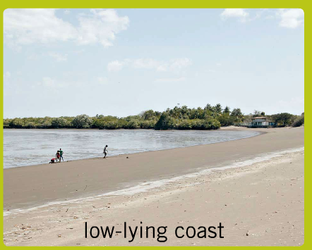
LOW-LYING COASTS: They are plains by the sea. They have sandy beaches. 

HIGH COASTS: They are high areas by the sea. They often have rocky cliffs.


LET'S THINK A MOMENT AND ANSWER THESE QUESTIONS:
  • Where can you see a high coast in Spain?
  • Where can you see a low-lying coast in Spain?


TYPES OF COASTLINES:


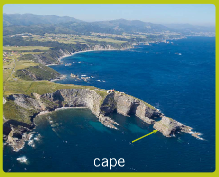
A CAPE: It is land which extends into the sea.

A GULF: It is a place where the sea extends into the land.


A PENINSULA: It is land which is almost completely surrounded by water.
AN ISLAND: It is land which is completely surrounded by water.

AN ARCHIPELAGO: It is a group of islands.

AN ESTUARY: It is a part of a river which opens into the sea.

A MARSH:  It is wet land near the mouth of a river. 


LET'S PLAY TO FIX YOUR KNOWLEDGE

viernes, 21 de marzo de 2014

MOUNTAINS and PLAINS in SPAIN (Unit 8-Science Y5)


We are going to start with a THINKING ROUTINE: THINK-PAIR-SHARE. 


  • THINK: During 1 minute you will think on your own about what you have learnt about Landscapes
  • PAIR: During 2 minutes you will talk with your partner about what you have thought. REMEMBER YOU HAVE TO TALK IN ENGLISH AND ALSO YOUR PARTNER, IF NOT YOU CAN SAY HIM OR HER. STOP! TALK TO ME IN ENGLISH.
  • SHARE: You will say to the whole class what you have thought or rememebered about the Landscapes. With your ideas the teacher will create a mind map in the blackboard. You can use this mind map to add all the new information you will learn today. 
In this video you will have a look about the highest mountains in Spain:
  • HAVE YOU EVER VISITED ANYONE OF THEM?
  • I HAVE VISITED...........................................

MOUNTAINS AND PLAINS IN SPAIN


  • Central Spain is dominated by a large plateau: CENTRAL PLATEAU. 
  • CENTRAL PLATEAU is divided into two parts by CENTRAL MOUNTAIN CHAIN.
  • THE PYRENEES is in the north it is the natural border with France.
  • THE BETIC CHAIN  is a chain in the south of the Central Plateau
  • Iberian Península has narrow coastal plains.
  • There are two depressions:
    • The Ebro Drepression in the north.
    • The Guadalquivir depression in the south. 

LET'S PLAY A BIT TO FIX ALL WHAT YOU HAVE LEARNT.


EUROPEAN CLIMATES (Unit 10-Science Y6)

Let's talk about the different climates in Europe. Please be careful and pay attention, this time you have to produce something and the end of the lesson.

As you know Europe is in the northern hemisphere. And there is a variety of climates. Have a look to this picture and try to interpret it, identify the places of the different climates.

  • Continental climate: in Central and Eastern Europe.
      • Winters are cold and summers are hot. 
      • Vegetation: grasslands with tall grass, and with low grass called steppes. 
  • Mediterranean climates: around the Mediterranean Sea.
      • Winters are mild and summers hot. 
      • Rainfall is light and in spring and autumn.
      • Vegetation: it used to be evergreen. 
  • Mountain climate: in the high mountain ranges.
      • Winters are very could and summers are mild.
      • It snows a lot.
      • Vegetation: forest.
  • Polar or tundra climate. In North Iceland and the north-east coast of Scandinavia.
      • It is cold all the year.
      • The treeless landscape of this climate is tundra. It includes moss and lichens. 

LET'S PLAY AND REVIEW YOUR KNOWLEGDE.


NOW IT'S YOUR TURN.
YOU WILL CREATE!!! 


Have you ever heard about the program WHO WANTS TO BE A MILLIONARE


With this app you will create a game to enjoy with all your partners. This is the process we will follow to achive the final product. 


  1. Read all the information about the climates in this post or in page 41 of the CB.
  2. Write fifteen questions about the European Climates. (Pay attention to the grammar: How to make questions)
  3. Show your questions and your answers to your teacher for him to check.
  4. Create and generate the game in the website.
  5. Enjoy playing it with your partners. 
  6. You will include it in the final post in your Kidblog at the end of this unit.

REMEMBER: 
WE ARE PLAYING BUT WE ARE LEARNING AT THE SAME TIME. 


miércoles, 19 de marzo de 2014

Connected Classrooms: Explore the Tundra with Polar Bears International and Google Street View

What are Connected Classrooms?
http://connectedclassrooms.withgoogle.com/#


Why are we going to explore the Tundra with Polar Bears International and Google Street View?


To know more information about this topic, we are going to work on page 39 A.B., Science Y6.


To take part on this connected classroom you have to write questions about Polar Bears on this wall.

We will be waiting for your attendance at 5.00 p.m. in Y6B class. 

It is a voluntary activity.

EUROPE: PHYSICAL FEATURES (Unit 10-Science Y6)

Let's move onto a new topic in our Science lessons we are going to study Europe and its features: physical and political ones.

First of all we are going to look for PHYSICAL FEATURES, secondly we will learn about CLIMATES, thirdly we will have a look to POPULATION AND DIVERSITY and we will finish with the EUROPEAN UNION.

Let's start with the PHYSICAL FEATURES OF EUROPE.

Have a look to this picture and try to answer the questions:

  • Where are the majority of mountain chains in Europe?
  • Which are the three longest rivers?
  • Which is the highest mountain?

This video may clarify some concepts about Geography of Europe with some photos and explanations.

Physical features of Europe.
  1. The Great European Plain:  From the Pyrenees to the Ural Mountains.
  2. Mountains: Most of them are in the South like the Alps or the Balkans.
  3. Compact groups of mountains: These are called plateaus, like the Central Plateau in Spain, or massifs, like the Central Massif in France.
  4. Peninsulas: (A piece of land which is almost completely sourrounded by water) like the Scandinavian or the Iberian.
  5. Islands: Like Iceland or the British Islands.

Coast and Rivers.

Europe has coastlines:
  • In the north with the Artic Ocean, the North Sea and the Baltic Sea.
  • In the south - east with the Caspian Sea.
  • In the south with the Mediterranean Sea and the Black Sea.
  • In the west with the Atlantic Ocean.
There are lots of rivers which cross Europe. The longest is Volga, which is 3.692 Km.

LET'S PLAY AND CHECK YOUR LEARNING. 

Activities

martes, 18 de marzo de 2014

THE LANDSCAPES (Unit 8-Science Y5)

We will start with a new topic THE LANDSCAPES. We are going to start thinking using a THINKING ROUTINE: The traffic lights. 

Let's draw a traffic lights in your notebook or in your Thinking notebook. 


And now during 3 minutes you will think about all the things you have already known about LANDSCAPES. And then classify it into the three colours:
  • GREEN: Write things you know and understand perfectly about LANDSCAPES.
  • YELLOW OR ORANGE: You know and understand something but you will need some help to go deeper on this things about LANDSCAPES.
  • RED: You don't understand or get these things or you want to know more about it during the time we are going to look for it in Science lessons. 

Once you have clear what you know, we are going to have a look to this video about LANDSCAPES. 

  • How many LANDFORMS does the video talk about?
  • What are these landforms?
  • Can you say me the definition at least of one of them?


THE LANDSCAPE

All the different features of the Earth's surface make up the landscape.


MOUNTAINS

MOUNTAINS are raised parts of the Earth's surface.

HILLS have lower altitude than mountains

Several mountains grouped together are called a MOUNTAIN RANGE. A long line of mountain ranges is called a  MOUNTAIN CHAIN

VALLEYS are low area between mountains. Rivers are often found in valleys.

PLAINS
They are large areas of flat lands with now hills or slopes.

A PLATEAU is a plain at a high altitude.

DEPRESSIONS are plains which are lower than the surrounding land.

COASTAL PLAINS are flat land near the coast. 

Let's practice all what you have learn during your Science lesson. Remember IT'S IMPORTANT TO PRACTICE TO FIX THE KNOWLEGDE IN YOUR MIND. 


EVALUATION ABOUT PARTNER'S VIDEOS ABOUT POLITICAL SPAIN (Unit 9 - Science Y6)

With this post we will keep on evaluating your partner's videos and mind maps following the rubric and answering to this form.


When you finish reading the rubric and you have everything clear about your mind, you can start watching your partner's video and answering the questions to evaluate it. 
IT IS VERY IMPORTANT TO HAVE CLEAR WHAT YOU HAVE TO LOOK FOR AND WHAT THE CRITERIAS FOR EVALUATION ARE.


You will send your evaluation through this Google Form. 
DON'T FORGET TO CLICK ON SUBMIT AT THE END.
To write the comments, you have to follow this pattern:
  • REDACCIÓN EN KIDBLOG: Tienes … puntos, porque…
  • ORGANIZACIÓN EN EL MIND MAP: Tienes … puntos, porque…
  • ESTRUCTURA DEL TEXTO: Tienes … puntos, porque…
  • ORTOGRAFÍA: Tienes … puntos, porque…
  • TÉCNICA GRAMATICAL Y TIEMPOS VERBALES: Tienes … puntos, porque…
  • VOZ Y RITMO: Tienes … puntos, porque…


VIDEOS ABOUT POLITICAL SPAIN (Science Y6)

Tengo el placer de presentaros los post publicados por los alumnos de 6ºB en la asignatura de Science.

Estos posts han sido publicados en el blog de aula:


Los alumnos han utilizado la herramienta de la web 2.0 POPPLET para hacer sus propios diagramas o mapas conceptuales sobre la unidad 9 POLITICAL SPAIN. 

Después han utilizado sus propios mapas conceptuales para construir un vídeo utilizando la web tool http://www.screencast-o-matic.com/

Ese vídeo es "upload" por ellos mismos a su propio canal de youtube para terminar con todo ello, en su propio blog, construyendo un post dedicado a resumir y entender mejor la unidad.

Aquí os dejo con cada post hecho por cada alumno.

    lunes, 17 de marzo de 2014

    EVALUATION ABOUT PARTNER'S OUR THE EARTH VIDEOS (Unit 7-Science Y5)

    With this post we will start with a new way of doing at the class, you are going to evaluate your partner's videos and mind maps following the rubric and answering to this form.


    When you finish reading the rubric and you have everything clear about your mind, you can start watching your partner's video and answering the questions to evaluate it. 
    IT IS VERY IMPORTANT TO HAVE CLEAR WHAT YOU HAVE TO LOOK FOR AND WHAT THE CRITERIAS FOR EVALUATION ARE.


    You will send your evaluation through this Google Form. 
    DON'T FORGET TO CLICK ON SUBMIT AT THE END.
    To write the comments, you have to follow this pattern:
    • REDACCIÓN EN KIDBLOG: Tienes … puntos, porque…
    • ORGANIZACIÓN EN EL MIND MAP: Tienes … puntos, porque…
    • ESTRUCTURA DEL TEXTO: Tienes … puntos, porque…
    • ORTOGRAFÍA: Tienes … puntos, porque…
    • TÉCNICA GRAMATICAL Y TIEMPOS VERBALES: Tienes …puntos, porque…
    • VOZ Y RITMO: Tienes …puntos, porque…

    VIDEOS ABOUT THE EARTH (Unit 7 - Science Y5)

    Tengo el placer de presentaros los post publicados por los alumnos de 5ºA en la asignatura de Science.


    Estos posts han sido publicados en el blog de aula:


    Los alumnos han utilizado la herramienta de la web 2.0 http://popplet.com/ para hacer sus propios diagramas o mapas conceptuales sobre la unidad 7 The Earth. 

    Después han utilizado sus propios mapas conceptuales para construir un vídeo utilizando la web tool http://www.screencast-o-matic.com/. Ese vídeo es "upload" por ellos mismos a su propio canal de youtube para terminar con todo ello, en su propio blog, construyendo un post dedicado a resumir y entender mejor la unidad.

    Más tarde lo han enviado a una asignación por EDMODO nuestra red social.

    Aquí, os dejo con cada post hecho por cada alumno.


    I am a sport journalist (English Y5)

    OBJETIVOS DE LA TAREA (Siguiendo Currículo Educación Primaria Castilla y León - Real Decreto 40/2007 de 3 de mayo):
    Al final de esta tarea el alumno será capaz de:

    • Elaborar textos escritos para describir personas y situaciones siguiendo patrones gramaticales previamente trabajados (Presente Continuo y Adjetivos Comparativos).
    • Usar formas y estructuras básicas incluyendo aspectos como el ritmo y entonación en el contexto de una grabación del texto descriptivo. 
    • Utilizar las TIC para la búsqueda de información y para la creación del producto final a llevar a cabo en la tarea. 
    • Reflexionar sobre su propio aprendizaje y organización del trabajo utilizando técnicas de autocorrección y evaluación. 

    ENFOQUE COMPETENCIAL. 
    • Competencia Lingüísitica:
      • El alumno será capaz de:
        • Escribir textos descriptivos basándose en la información buscada por ellos mismos. 
        • Utilizar los códigos de comunicación propios de la descripción.
    • Competencia Digital y tratamiento de la información:
      • El alumno será capaz de:
        • Dominar y aplicar a diferentes situaciones y contextos diferentes lenguajes: visual, icónico, textual, gráfico, etc...
        • Generar producciones serias, responsables y creativas.
        • Comenzar a identificar estrategias a utilizar para resolver situaciones y problemas con el software y el hardware utilizado.
    • Competencia Cultural y Artísitica:
      • El alumno será capaz de:
        • Disponer de habilidades de cooperación y tener conciencia de la importancia de apoyar y apreciar las iniciativas y  contribuciones ajenas.
    • Competencia de Aprender a Aprender:
      • El alumno será capaz de:
        • Organizar el trabajo planteándose metas a corto, medio y largo plazo. 
        • Plantear actividades y organizar los tiempos.
    • Competencia de Autonomía e Iniciativa Personal.
      • El alumno será capaz de:
        • Tener una actitud positiva al cambio.
    DESCRIPTOR PORTFOLIO

    • COMPRENDER A2+: Comprendo expresiones en mi escuela cuando me habla mi profesor y mi compañero, comprendo cuando me dan mensajes cortos y sencillos, como instrucciones o audios.
    • LEER A2+: Comprendo textos breves y sencillos; se encontrar informaciones y datos en páginas web.
    • CONVERSAR A2+: Me comunico en conversaciones sencillas sobre temas del colegio; participo en conversaciones sencillas sobre los deportes.
    • HABLAR A2+: Utilizo muchas expresiones y frases sencillas para describir actividades que hago en la escuela como entrevistas deportivas.
    • ESCRIBIR A2+: Escribo textos sencillos sobre cosas personales como diferentes deportistas.
    EXPLANATION OF THE ACTIVITY.

    After a couple of week learning about Present Continuous, Comparative Adjectives and sports you are ready to be a 'Sport Journalist'.

    In this presentation you will see what the aim and the process for the task will be:


    EVALUATION PROCESS.
    • Teacher's evaluation will be done with the following rubric. 28 posible points (60% of the final mark).


    • Self-evaluation will be done with the following bullseye and the previous rubric. 28 posible points (20% of the final mark).
    • Peer's evaluation will be done with the following worksheet. You have to come to an agrement with your classmate about your mark of your teamwork. 28 posible points (20% of the final mark).